


Over 2 Million Downloads

4.6 out of 5
Over 5,000 5 Star Reviews

RAD NAV APP
I use Savvy Navvy daily for all my inshore fishing here in south Texas. Great for current conditions, including tides and wind direction. It’s like Google maps for boaters. Plan routes, mark your fishing spots and return to the dock in one piece. Every time! Great App 5 stars.
Lifesaver!
2 weeks ago during the heatwave, we were on the Solent and the temperature fried all our instruments including the GPS plotter. Thank god we had Savvy Navvy as it worked perfectly for the entire weekend and allowed us to do everything we wanted. People say these kind of apps aren’t meant to replace the instruments on board, well I can confirm that when they instruments on board all fail, this was an absolute lifesaver. Can’t wait to test it in other countries.
Great and simple to use
I sail with friends and families and this app is a great way to illustrate “dads” boring chart work through a much more teenage friendly platform. I use both for cross reference and find it pretty accurate. Considering the price of charts it is extremely good value.
Innovative Technology that
Makes Navigation Easy

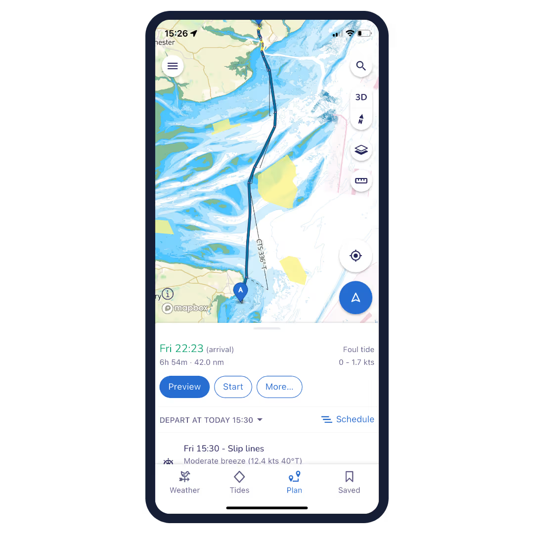
Plan Your Route
Drop pins to mark your start and finish locations (as well as any waypoints you like in between) and the savvy algorithm will automatically calculate the best route based on chart, weather and tidal data as well as the bespoke settings for your vessel.


Export Route to your GPS Chart Plotter
Once you’ve plotted your route with savvy navvy you can easily upload it for use with your GPS chart plotter. Simply tap Export Route to receive the details as a GPX file that can then be uploaded to your marine GPS chart plotter of choice.

Automatic Course to Steer
Just like your chart plotter savvy navvy acts like a handheld marine GPS by providing routing details and an automatic course to steer on your phone or tablet. Once you’ve plotted your route you can tap “Preview” to get an overview of the route before uploading it to your chart plotter.


Modern digital Savvy Charts™
Sleek, easy to use, digital Savvy Charts™ ensure the app interface is designed with usability in mind, showing you all the essential nautical information you need without over cluttering the screen with excessive detail.

GPS Location Positioning
Just like your marine GPS chart plotter you can track your position in the savvy navvy app on your phone or tablet. Switch to “GPS” mode where you will see your live position as well as your course over ground, speed over ground and distances to key locations and landmarks around you.


Automatic ETA Information
Get an automatically estimated time of arrival when plotting a route with savvy navvy. Our intelligent algorithm calculates your ETA based on the chart, weather and tidal data to ensure your prediction is as accurate as possible. You can then share your route with friends and family so they know when to expect you.
And Many More Amazing Features!
Anchor Alarm
Rest easy when anchoring overnight with the savvy navvy anchor alarm. Set your “safe zone” and the app will sound an alarm if you drift outside it.
Marina and Anchorages
Ensure you pick the best place to stop for lunch or an overnight stay with our integrated Navily and Dockwa features. See user reviews, local facilities as well as detail on seabed holding and photos of the location.
Night and Satellite Views
It’s nice to have options. That’s why we give you the option to view your digital charts in map, satellite and night mode, so your app interface can adjust with you to fit your requirements.
Offline Chart and Weather Packs
We all love to explore beyond the horizon, that’s why savvy navvy lets you download offline weather and chart packs so you can continue to use all the navigation tools you know and love even when out of range of WiFi or phone signal.
Save Routes
Got a favourite route? Planning ahead of time and want to keep your route safe to ensure you can use it again? No problem, simply select “Save Route” in the savvy app and we’ll store it on your device for use at a later date.
Customer Support for Boaters
We are with you anywhere in the world with our team of dedicated customer support team who act as your silent first mate, ready to answer any questions you have along the way. With us, you never sail alone.

Ready to go Boating?
Download savvy navvy to get planning.
The savvy navvy boating app is available on Android or iOS with a 14-day free trial.

